Tunnel Falls Hike in Southington, CT; Trail Guide
A short hike with exceptional sunrise views facing east that would be pretty any time of day! With views at the top and a trail that hugs Roaring Brook with views of Great Unconformity Falls at the top (yes, that’s the name!).
In just 3.1 miles this centrally located CT hike packs a lot and I’d love to go back and actually check out the falls (Great Uncomformity Falls) a little better.
It can be a little tricky to find the views here and in the second half of this post I TELL YOU EXACTLY HOW TO FIND THE LOOKOUT! Scroll down to the Trail Guide section if you’re short on time. 🙂
 West Peak & Hubbard Park in distance!
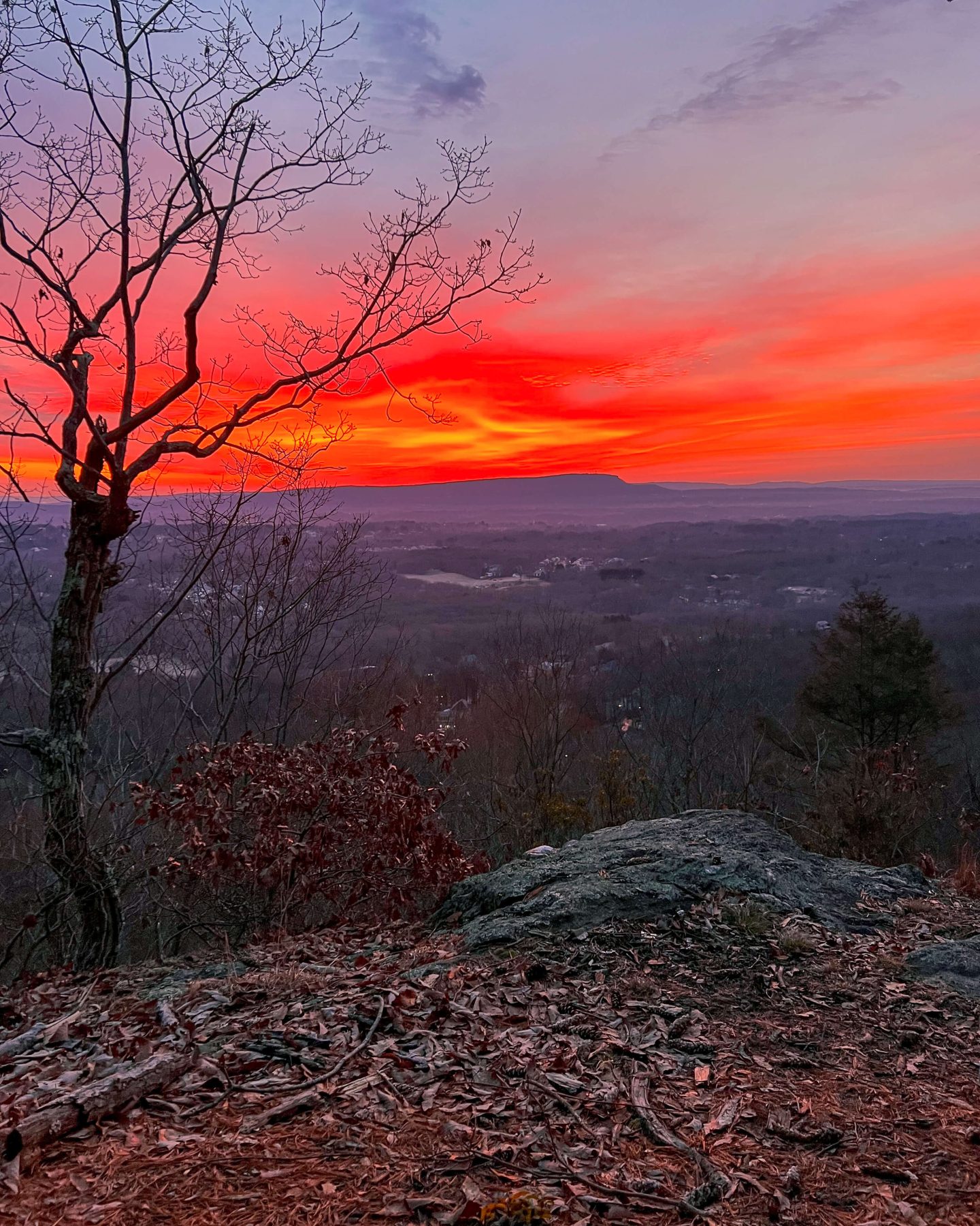 About 15 minutes before sunrise..
📖 Background you can feel free to skip: It was a chilly morning (approximately 5:15 am) in early January, Jared and I were getting ready to go on a sunrise hike.
Originally, we had plans to drive an hour to the shoreline to catch a sunrise at Hammonasett State Park. We were going to hike at Meig’s Point which faces east.
But the morning came and for some reason, it had just dawned on us – will the gate to Hammonnasett be closed?! Is there a gate? So, each on our phones, we Googled and zoomed in on Google Maps to see if we could spot a gate to Hammonasett State Park.
At almost 5:45 now I thought, let’s just go somewhere around here. But where?! We’ve done so many of the sunrise (eastern facing) lookouts around us.
And then I remembered this hike in Southington – Tunnel Falls, it was about to make all our sunrise dreams come true!
So hurriedly, I finished getting dressed and we made it to the parking lot for Tunnel Falls at 6:30 am. The sun was rising at 7:12 am and we had a 1.6 mile walk with 500 feet of elevation ahead of us.
On the way over in the car we ALREADY started seeing the sky to the left of us, in the east, turn a smoldering red color.
It was about to be a good one…

🥾TRAIL GUIDE: Tunnel Falls via Blue Blazes Trail
OVERALL RATING: (OUT OF 5 STARS) ⭐️⭐️⭐️⭐️ and a half!
MILES: 3.1 MILES
📈ELEVATION GAIN: 534 FT
LEVEL: MODERATE
🚗PARKING: Small lot on Whitman Rd, off Mount Vernon Rd.
➡️➡️ Click to navigate here: 41.6009, -72.92608
TERRAIN: Flat even paths to rocky river bed 🪨
🐶DOG-FRIENDLY: YES 🙂
Streams for water and Roaring Brook at the top
KID-FRIENDLY: Yes
There is nothing technical about this trail, but you do walk along a rocky river bed for a little bit so I could see their little shoes going this way and that. 🤔 A good boot or sturdy shoe will prevent any ankle mishaps!
PEACE AND QUIET 🤫☮️: Yes, depending on the time of day…
This trail is right above the Southington Sportsmen’s Club, a private club where, yes, they practice shooting. I don’t know what they shoot at or what it looks like but I assume that since there’s a mountain and trail right above them their targets are low and they know what they’re doing being in and amongst trails. There’s even a neighborhood and houses you walk behind, too.
With how early we went, the club was closed. I tried finding out the hours online but didn’t see them listed. If concerned, here’s a number (860)628-9506 but, this is a fairly popular trail and I’m sure they know what they’re doing!
The point is, if you don’t want to hear guns firing then go here early like we did or call the number to see when they’re closed.
SAFETY:
I was with Jared and the dogs but I didn’t get any weird vibes in here. There are those trails that you for some reason think, I wouldn’t enjoy hiking here alone. This isn’t one of them. There is an area at the top that looks like you can get to it from an old logging road and it looked like some construction or water authority property at the top. That’s one thing I want to look into next time is if you can drive to the top here. If so, then if hiking alone I would wonder if I’m going to see someone at the top that somehow drove. I wi keep you posted on that though!
🗺 Tunnel Falls Trail Guide 🗺
0-0.1 miles From the car find the Tunxis Trail sign with the blue blazes, letting you know where to start the path and enter the trail tunnel!

0.1-0.6 miles Here you’ll walk up half of the elevation of this hike, about 250 feet in half of a mile. So it’s a steady uphill but nothing too crazy. The path here is pretty even with some rocky parts. Nothing technical here though.
There is some water runoff here as this trail hugs a brook on the way up. And on a winter day in January, there were some icy patches on the rocks that you had to be careful of and walk around. We did not need microspikes here.

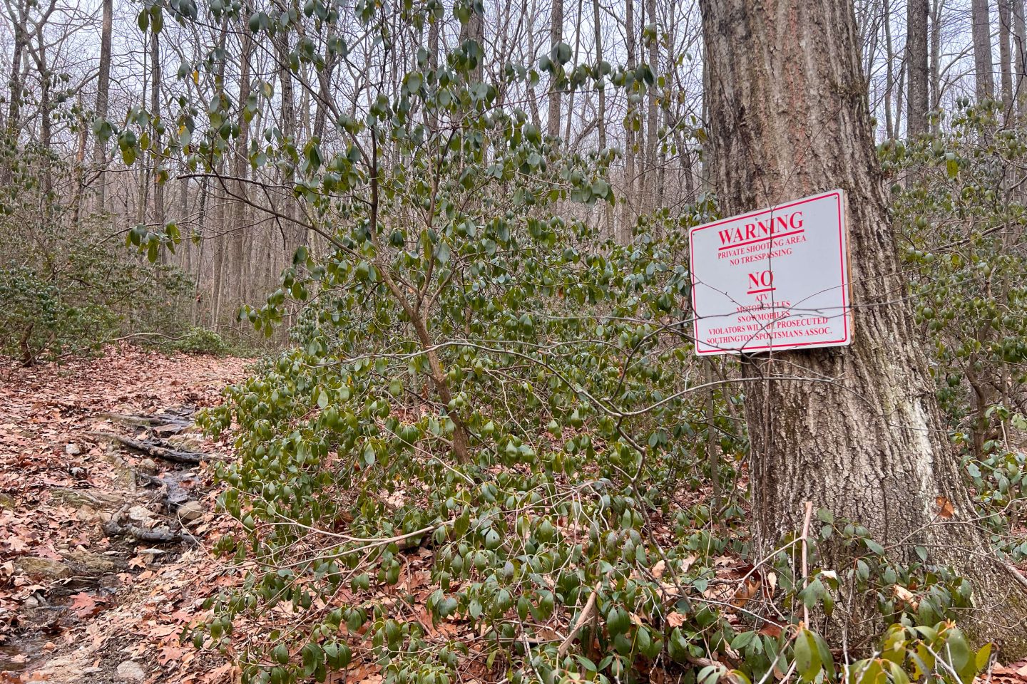
You will notice the “No Trespassing” signs here that encourage you (or scare you rather 🥴) to stay on the trail. You are on the right track if you see these signs they are just trying to prevent you from wandering to the right into the woods since the Sportmen’s shooting club lives in there. 👀
0.6 – 1.4 miles At the 0.6-mile mark, you will notice a fork in the trail. You can go either right or left here. AllTrails has you staying to the right on the blue trail (you’ll see it painted red and blue here). Whether you go left or right both paths meet just 0.2 miles later to put you back on the blue trail.

You contunue to walk up along the ridge here and gain the rest of the elevation, about 220 feet, in this 0.8 mile section.
This section is similar to a dried-up river bed. Walking along the rocks can feel wobbly if you have weak ankles. That’s why I always wear my high-support Merrel boots even for simpler hikes. I’d rather keep my foot sturdy then wear a hiking shoe and be wobbling around.
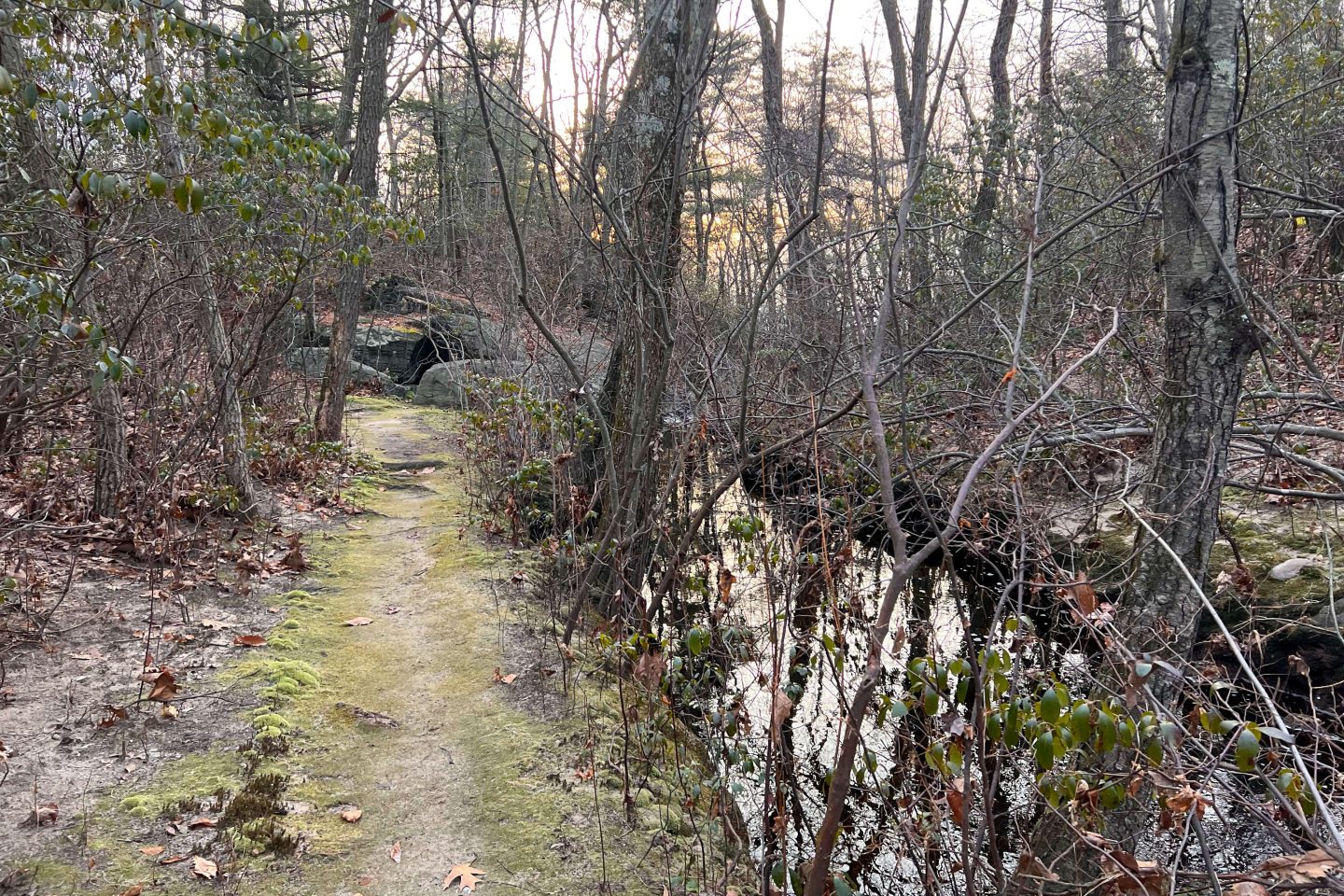
I loved the tunnel of low bushes, moss, and mountain laurel here.
1.4 – 1.5 miles From what I read on AllTrails reviews, this is where people have gotten mixed up and haven’t been able to find the lookout.
So I am going to describe the path to you, carefully, here so you don’t miss the views! ⬇️👇🏼
At the 1.4-mile mark, the trail opens up to a clearing with a logging road to the left and ahead of you and a brook (Roaring Brook) running right in front of you.

Walk across the little bridge going over the brook. Then turn right and walk TOWARD the cement blocks. (Now you are on the left side of the brook).
There is a trail right behind the cement blocks so keep walking towards them and enter the woods onto the path.

I forget what Jared called this little path that runs along the brook, but this short section of the trail that leads you to the lookout is quite magical! Wow.
Walk along the mossy path through a tunnel of bushes as the trail leads you to the lookout which you’ll arrive in just 0.1 miles.
There used to be a bench at the top here which I was looking forward to putting in a photo with the sunrise but it’s not there anymore. Whoever built it, maybe they will go back and do another!
From the lookout you can see the west side of Southington below as well as far into the distance to Hubbard Park. You probably won’t be able to see Castle Craig (unless you bring binoculars) but you’ll be able to make out the silhouette of West Peak in Hubbard Park.
 Wow, what a sunrise it was!
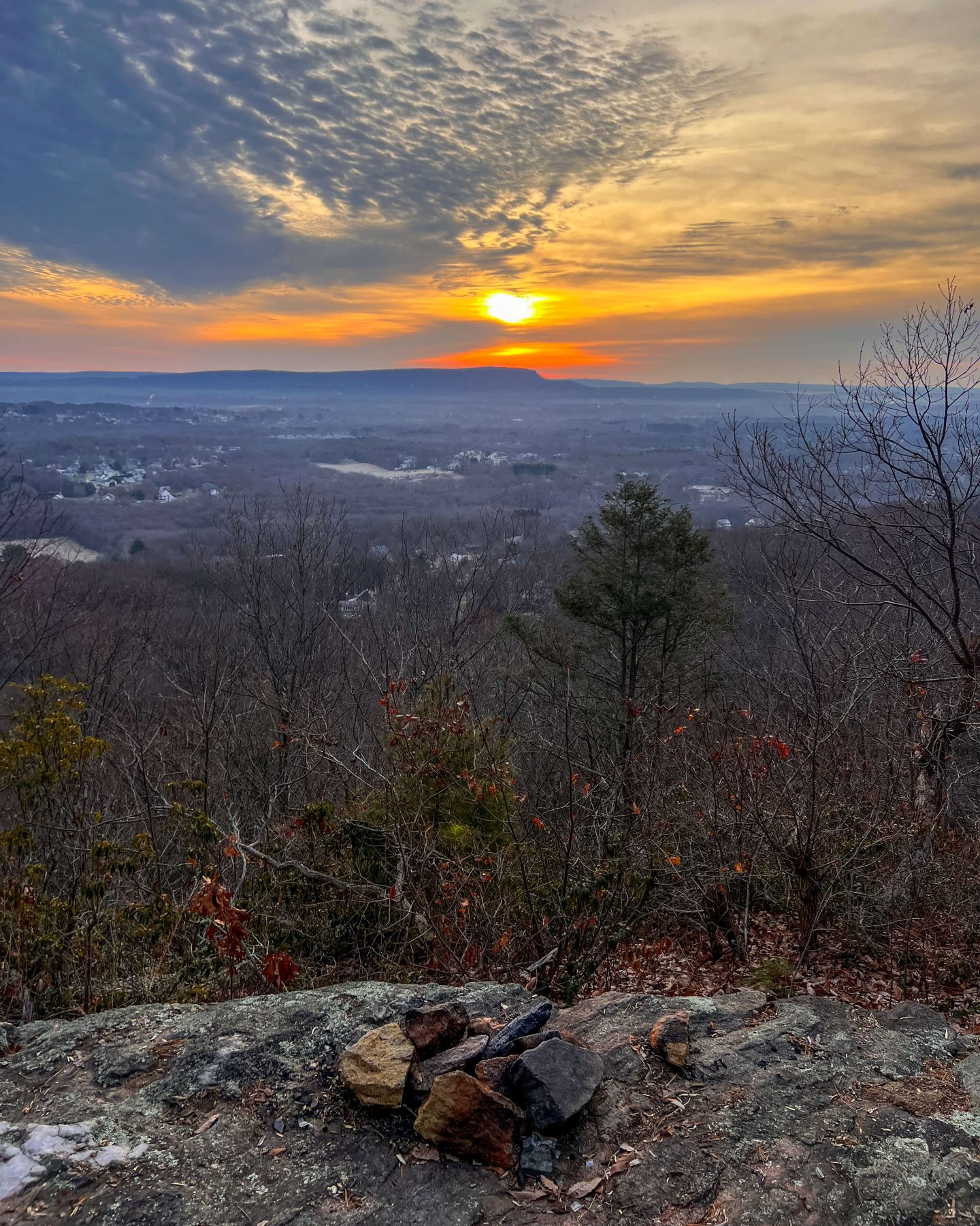

And don’t forget to check out the waterfall – Great Uncomformity Falls, right below the lookout. There is no actual trail down to the falls though so be very careful if you do wander. The rocks around waterfalls can be deceptively slipper!
When you are done taking in the views and Great Uncomformity Falls, turn around and head back the same way you came up! Taking a left after the cement blocks to cross the bridge.

I hope you enjoyed this trail guide to Tunnel Falls in Southington, CT. For another trail in the area check out my guide on Compounce Mountain & Julian’s Rock that’s super close by!