18 Best Views & Hikes In and Near Lake George; All Levels!
Want to add some adventure to your Lake George vacation?! I’ve compiled a list of 18 of the best hikes in and around Lake George ranging from just 1.1 miles in length to over 7 miles – sunrise to sunset views!

In this post, you’ll find hikes on both the east and western sides of Lake George that overlook the lake, and some that are a further drive if you’d like to venture out of the main LG area.
Zoom in to see the 18 different hikes pinned all around the lake in the order they appear here in this post. 🙂
This Lake George hiking post is split into 2 sections;
- Part 1 features 8 of the best hikes around Lake George under 3 miles
- Part 2 features 10 hikes over 3 miles! 🙂 So whether you have the whole day or just a couple of hours, you’ll know what your choices are!
Also included are special highlights of each trail, its link on Alltrails, and a link to navigate to the parking 🚗 because we all know how hard it can be to find the trailhead lot sometimes! And all hikes allow dogs unless otherwise noted in the title. 🐶✅ (Check out this dog-friendly glamping where we’ve stayed near Lake George!)
Growing up and living in central Connecticut, Lake George is always on the docket for me to visit for a weekend hiking trip since it’s only a 2-3 hour drive. Staying for weekends several times a year over the years has allowed me to collect my favorite hikes around the lake as well as those outside the main Lake George area that I think are worth driving to if you have a little time.
This list comprises hikes I’ve done with my personal experience and photos and Lake George area hikes I still have saved on AllTrails for next time so you don’t have to do all the research yourself!
 #3 on the list
- #7 on the list
- #6 on the list
- July 2022
- #10 on list


Even though most of these hikes are right around the lake, don’t underestimate the time it may take to get to some of them depending on where you’re staying. (Here’s a fun pet-friendly stay just 10 minutes from downtown Lake George!)
What I’ve learned is that Lake George is HUGE! At 32 miles long it can take almost an hour to get from the southern tip of Lake George to the top in Ticonderoga.
So let’s get to the best hikes in and around Lake George! ⬇️
🥾Part 1: Best Shorter Hikes around Lake George (Under 3 Miles)
1. Blue Trail to Bradley’s Lookout, 1.1 miles, easy

Could this 1.1 mile hike be the best hike in Lake George?! Look at that view. 😍 I’d say it’s the best hike to do in Lake George for sunrise for sure! 💯
Located on the western side of Lake George near Bolton Landing, this is the perfect Lake George hike if you want views of the lake but also want to keep it super short.
The views here face east over the lake making it a perfect spot for sunrise!
- Miles: 1.1 miles
- Elevation gain: 183 feet
- Difficulty: Easy
- Time: under 1 hour
- Parking: Click here to navigate to 43.55678, -73.68155. (Large parking lot)
- Special features: Faces east over the lake, great for sunrise! 🌅
2. Up Yonda Farm Full Loop, 1.3 mile loop, moderate, NO DOGS 🐶 allowed

Also near Bolton Landing on the western side of Lake George, this hike has views facing east over the lake as well. This short hike is not one I’ve done yet as we are usually traveling with our dogs and this is a no dogs allowed hike. 🙁
Up Yonda Farm is an Environmental Education Center that kindly allows visitors to use their property for a hike with a $5 per vehicle day use fee requested when you park. Pay at the Farmhouse during open hours or pay online during off hours. The gravel section of the base loop is wheelchair accessible.
- Miles: 1.3 miles
- Elevation gain: 282 feet
- Difficulty: moderate
- Time: under 1 hour
- Parking: Click here to navigate to 43.57637, -73.65464. Parking at Up Yonda Farm, $5/car
- Special features: Faces east over the lake, great for sunrise! 🌅
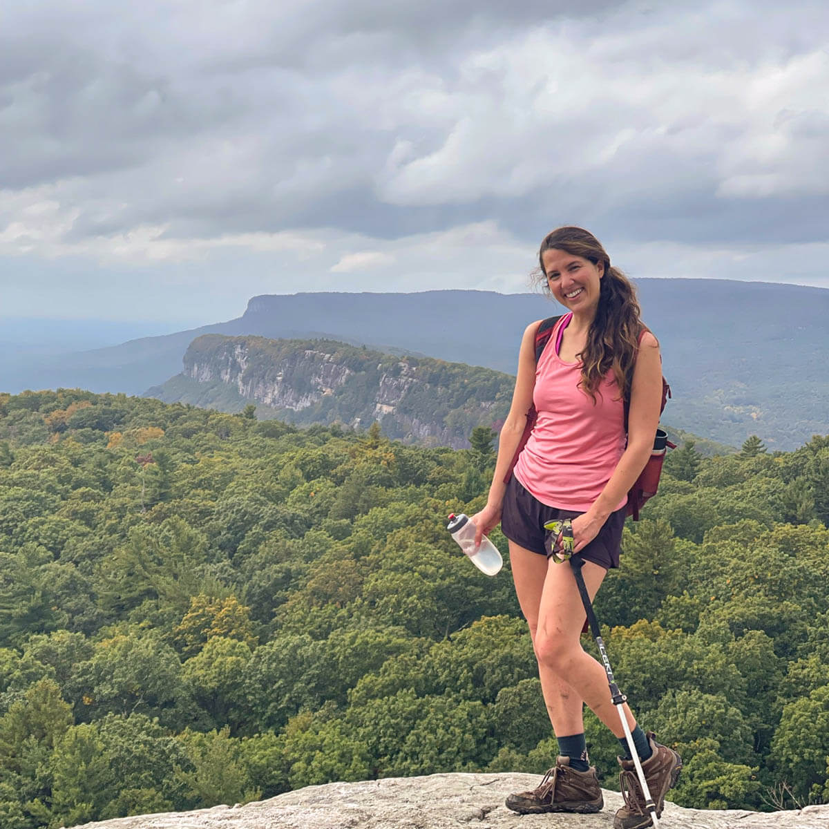
3. Western Ridge Trail to Overlook, 1.8 miles, Moderate

South of Lake George is the 6,250-acre Moreau Lake State Park. Located right along the Hudson River, the park has camping, hiking, and access to a beach.
I loved this short walk up to a wide-open view over the Hudson River. There are lots of trails in here so just keep following the Yellow markers.
- Miles: 1.8 miles
- Elevation gain: 511 feet
- Difficulty: moderate
- Time: 1-2 hours
- Parking: Click here to navigate to 43.22065, -73.76493. Large lot
- Special features: View over the Hudson River as it hooks toward Corinth
4. Buttermilk Brook – Bear Slides, 1.9 miles, Easy

Located in Lake George Wild Forest, the Bear Slides are smooth rocks with water running over them creating tons of ‘slides’ AKA slippery rocks! I imagine this can be a popular spot on a hot summer day so take note if you’re visiting then
We loved it here in the fall. The trail runs along the left side of Buttermilk Brook. The dogs had fun running along the trail, taking water breaks in the brook and walking along the rock slides. Just watch your step if you choose to walk on the slides. Wet rocks are slippery!
- Miles: 1.9 miles
- Elevation gain: 344 ft
- Difficulty: easy
- Time: ~1 hour+
- Parking: Click to navigate to parking lot here 43.4009, -73.88015. A note from AllTrails: It is easy to get confused at the trailhead, downloading the map ahead of time is recommended. Take the trail marked on the map that goes right and do not walk on River Road.
- Special features: Buttermilk Brook along the right side of trail, small waterfalls, and lots of rock slides
5. The Pinnacle via Red Trail, 2.1 miles, moderate
 Bauer and Captain, February 2022
- Captain looking out!
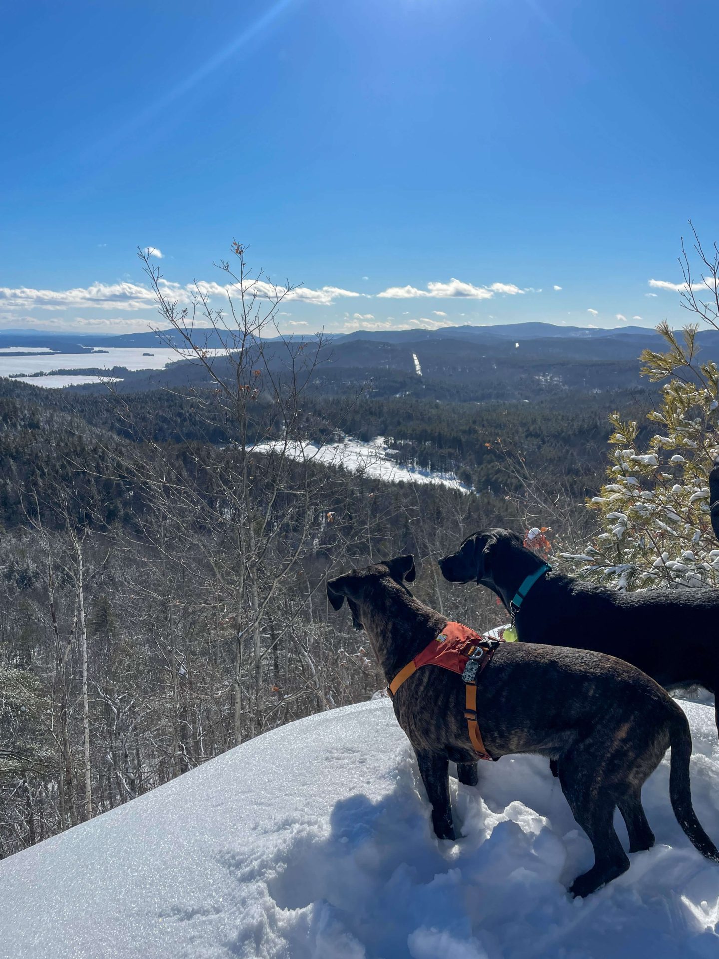

Located on the western side of Lake George near Bolton Landing, from the same large parking lot and trail as Bradley’s Lookout (#1 on the list).
At just 0.1 miles into the trail there’s a sign and trail juncture. Head to the left toward The Pinnacle (pictured above) or head to the right for Bradley’s Lookout (the first hike on this list). This is another great one to do if you want similar views as Bradley’s Lookout but with a longer walk!
- Miles: 2.1 miles
- Elevation gain: 495 feet
- Difficulty: moderate
- Time: 1 – 2 hours
- Parking: Click here to navigate to 43.55679, -73.68174
- Special features: Views facing east over Lake George, great for sunrise! 🌅
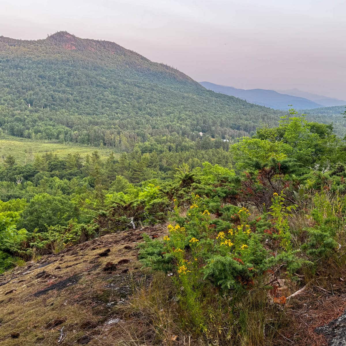
6. Potash Mountain, 2.8 miles, Moderate
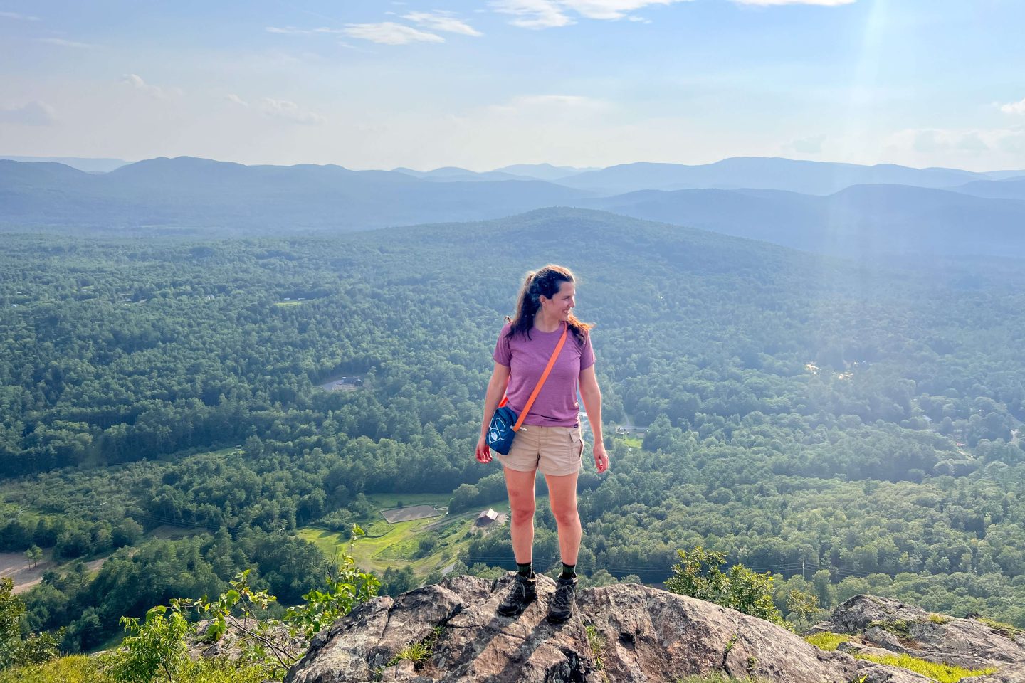 A hot day in the jungle 🎒☀️
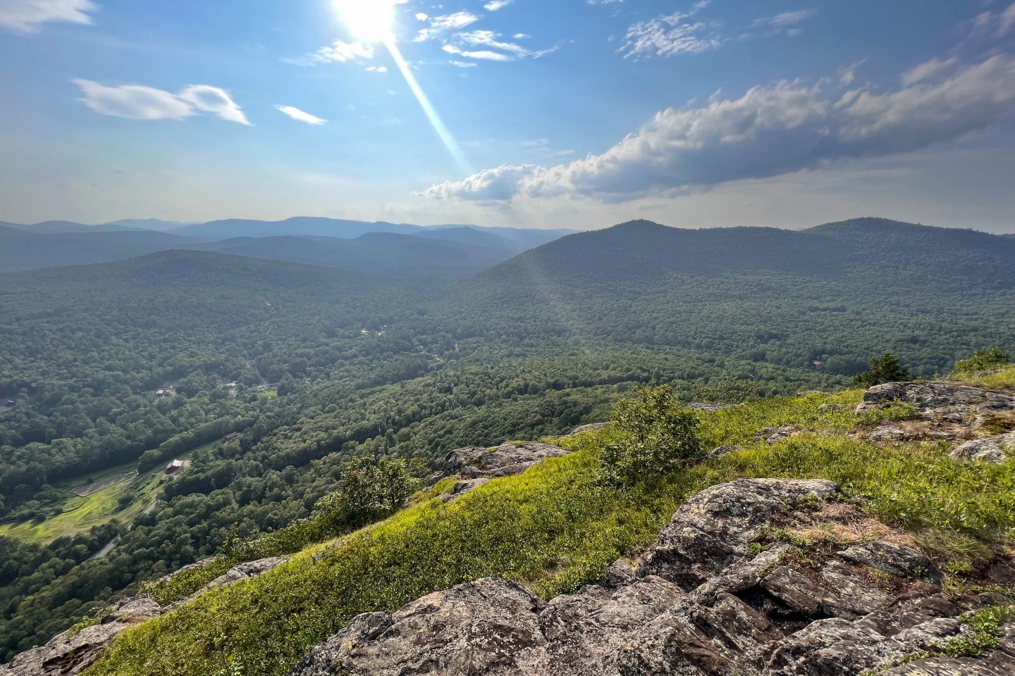 July 2023
In between Lake George and Lake Luzerne, just below the southern tip of Lake George, is a steep little climb to the top of Potash Mountain.
At 1,751 feet tall, Potash is Lake Luzerne’s highest peak. I loved the wide-open, rocky summit views at the top in the fall. I imagine it’s beautiful up here any time of year!
- Miles: 2.8 miles
- Elevation gain: 1,026 feet
- Difficulty: Moderate
- Time: ~2 hours
- Parking: Click here to navigate to 43.36884, -73.82743
- Special features: Highest peak in Lake Luzerne area
7. Shelving Rock Mountain Trail, 3 miles, Moderate
- Sunset in September 2023
- Shelving Rock is the perfect spot for sunset!


Located on the eastern side of Lake George, in Lake George Wild Forest 😍 this hike is a must if you’re staying on the right side of the lake.
Overlooking Lake George with views facing west, we did this hike for sunset in early fall and it did not disappoint! Watching the last of the boats zip to their home on the lake, and seeing the sun dip behind it, made for the perfect night. I only wish we had brought more snacks for the top!
- Miles: 3 miles
- Elevation gain: 718 feet
- Difficulty: Moderate
- Time: 1.5 – 2+ hours
- Parking: Click here to navigate to 43.55554, -73.5985Large lot
- Special features: Views facing west over Lake George, perfect for sunset! 🌅
8. Thomas Mountain, 3 miles, Moderate
Another shorter hike on the western side of Lake George near Bolton Landing (the 3rd one on our list!).
The trail up to Thomas Mountain follows the remains of an old logging road where there is the remains of an old cabin (the Thomas Mountain Cabin site). I love walking up those logging roads as you don’t have to worry about rocks and roots along the way!
- Miles: 3 miles
- Elevation gain: 767 feet
- Difficulty: Moderate
- Time: ~1 – 2 hours
- Parking: Click here to navigate to 43.60362, -73.69306
- Special features: Narrow view facing east over Lake George
🥾 Part 2: Best Longer Hikes around Lake George (Over 3 Miles)
9. Spruce Mountain Fire Tower, 3.1 miles, moderate
 Sunset, July 2023
 Look at that view! 🤩
This is a good one to do if you are in or staying near the southern part of Lake George since it’s about 30 minutes south, just below Corinth.
The highlight of this trail and the reason for the drive is the 73-foot fire tower on Spruce Mountain’s 2,009-foot. The summit is only accessible by NYS DEC marked 1.2-mile hiking trail with yellow markers.
⚠️ Note: due to the trail crossing the Blue Jay Hunting Club, the upper portion is closed from late October through early December during hunting season. ⚠️
- Miles: 3.1 miles
- Elevation gain: 1,020 feet
- Difficulty: Moderate
- Time: 2 hours
- Parking: Click here to navigate to 43.20174, -73.89567
- Special features: Fire tower at the top with 360-degree views!
10. Hadley Mountain Trail & Tower, 3.2 miles, hard
- Atop Hadley Tower, 10/23
- Saying hello to fall!


Just under 40 minutes from the southern tip of Lake George is another tower offering in Wilcox Lake Wild Forest with terrific views in all directions. And if you’re afraid to climb up, Hadley Mountain itself has an open summit with great views to the east, south (including the Great Sacandaga Lake), and west.
We did this hike at the end of a multi-day hiking weekend and I found it difficult so I’m not surprised that AllTrails rates is ‘Hard’. The trail isn’t too technical it’s just a lot of elevation (~1,500 ft) in just 1.5 miles! It’s all up, up, up from the moment you start. But, I found the kids running down the mountain as I was huffing and puffing on the way up, encouraging! If they can do it, we can too. 🙂
- Miles: 3.2 miles
- Elevation gain: 1, 525 feet
- Difficulty: Hard (lots of elevation in short amount of time)
- Time: 2.5 hours
- Parking: Click here to navigate to 43.37386, -73.95063
- Special features: Hadley Fire Tower at the top with 360-degree views!
11. Prospect Mountain, 3.3 miles, Hard

Located just minutes from the downtown southern tip of Lake George is this POPULAR hike on the western side of the lake with views facing east out over the lake. (We’ve had at least 4 of these on our list!)
This trail is unique in that it’s all along an old tramway trail running from Lake George Village to the top of Prospect Mountain with views of the southern end of Lake George. The tramway was once the largest cable railroad in the world! Wow.
What makes it populated is the optional drive up the toll road to the top of the mountain for just $10. There’s even a shuttle bus that takes people up and picnic areas at the summit. If you want a more peaceful forest hike and experience do this one super early in the day or choose another hike. 😍
- Miles: 3.3 miles
- Elevation gain: 1,522 feet
- Difficulty: Hard
- Time: 2.5 – 3 hours
- Parking: Click here to navigate to 43.42553, -73.72023. Parking along Smith Street
- Special features: Hike along an old tramway trail which was once the largest cable railroad in the world! Views facing east of southern Lake George
12. Pilot Knob Ridge, 3.8 miles, hard

Finally, a hike on the eastern side of Lake George! Located in Schumann Preserve in Pilot Knob, this ‘hard’ trail gets its difficult rating from the steep elevation in less than 2 miles. The trail maintenance here helps though. For at the steeper sections there are thoughtfully placed stone steps so you can just focus on putting one foot in front of the other!
No technical climbs, just a good workout. Enjoy the view facing west looking out over Lake George!
- Miles: 3.8 miles
- Elevation gain: 1,328 feet
- Difficulty: Hard
- Time: ~3 hours
- Parking: Click here to navigate to 43.47173, -73.6258
- Special features: View looking west over Lake George, great for sunset! 🌅
13. Cat Mountain via Red Trail, 4 miles, moderate

Back to the eastern side of Lake George now in the Cat and Thomas Mountains Preserve near Boltons Landing. But this time, it’s a moderate hike that does not cram 1,500 feet of elevation in under 2 miles!
This is more of a steady, gentle climb of 1000+ feet spread out over 2 miles. Ahhhh….🧖 (feeling pampered). Take note that this trail is not as well marked as others in the area so I suggest downloading the AllTrails map before you go.
Like other ‘best hikes’ near Lake George this one, too, has a view out east over the lake. It would be great for sunrise!
- Miles: 4 miles
- Elevation gain: 1,128 feet
- Difficulty: Moderate
- Time: 3 hours
- Parking: Click here to navigate to 43.5762, -73.68526
- Special features: View east over Lake George, great for sunrise 🌅
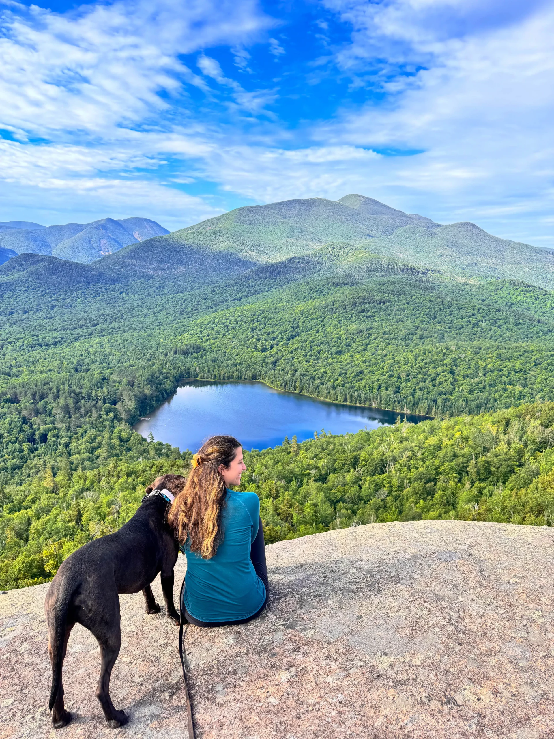
14. Goodnow Mountain, 4 miles, moderate
 July 2022
- Tower view from top of Goodnow Mtn

While this hike is an hour from the southern tip of Lake George, I wanted to include it for its truly magnificent views that make you feel like you’re at the top of an Adirondack high peak! Maybe that’s because this one is located in Adirondack Park!
Even when we’re home for a weekend we drive around an hour to go hike so when we stayed in Lake George we treated it like any other weekend. An hour drive in the morning here, and made it back in time for lunch or to shower for dinner in Lake George.
That’s what it’s all about, right?! 🙂 I don’t think you’ll regret making the little trip if you are staying in the area for more than a night.
- Miles: 4 miles
- Elevation gain: 1,076 feet
- Difficulty: Moderate
- Time: 3 hours
- Parking: Click here to navigate to 43.96968, -74.21442, large lot
- Special features: Old fire tower at the top, only the bottom stairs area climbable. Stunning views of Rich Lake and surrounding ADK mountains.
15. Buck Mountain Trail, 6.1 miles, hard

Located on the wild wild western side of Lake George in Lake George Wild Forest the views from Buck Mountain make this one a must for a best hiking near Lake George list.
But I still have this one on my “list” so for now I am going to provide you with the facts delivered straight from AllTrails so you can still get to this one!
From AllTrails: “The first mile of the hike is on a primarily wide trail with a slight grade. There is an intersection that leads to several other summits not too far in – be sure to maintain your trail markers. The ascent through mile 2 becomes steeper and has rocky sections with a few easy stream crossings. The views slowly start to come during the last mile or so of the hike as the canopy recedes and the rocky scrambles begin. Some of the scrambles may require a hands on approach so care should be taken with the younger hikers. The view from the summit is well worth the hike.” ✅
If you get to this one before I do (you’ll know that because you’ll be reading this!) then comment below and let me know how it is. 🙂 I’d love more encouragement to plan another hiking weekend at Lake George.
- Miles: 6.1 miles
- Elevation gain: 1,988 feet
- Difficulty: Hard
- Time: 4+ hours
- Parking: Click here to navigate to 43.50920, -73.63050
- Special features: Views facing west out over Lake George, great for sunset! 💦
16. Pole Hill Pond Blue Trail, 6.2 miles, Hard
Another best hike in Lake George along the eastern side near Bolton Landing! From the top, there’s a nice view facing east over Lake George from Walnut Ridge plus you get views of Pole Hill Pond as the trail circles around the water.
As other reviewers on AllTrails have said, this trail is poorly maintained compared to others in the area. Keep your head up and eyes out for markers and perhaps download the map ahead of time!
- Miles: 6.2 miles
- Elevation gain: 1,558 feet
- Difficulty: Hard
- Time: 4 hours
- Parking: Click here to navigate to 43.61447, -73.62228
- Special features:
17. Shelving Rock Mountain and Shelving Rock Falls, 6.3 miles, Moderate


Earlier in the list we saw the shorter 3 mile hike to Shelving Rock Mountain where you have wide open sweeping views over Lake George, facing west.
And if you want those views and a waterfall and you’re willing to put in the work, then check out this trail that combines both. Located on the eastern side of the lake you’ll climb to the top of Shelving Rock for views first then down to the lake where you’ll explore the shoreline around Log Bay and Shelving Rock Bay.
You’ll walk by the beautiful Shelving Rock Falls twice on this hike. Be careful on the rocks around the falls as they are slippery.
- Miles: 6.3 miles
- Elevation gain: 1,046 feet
- Difficulty: Moderate
- Time: 3+ hours
- Parking: Click here to navigate to 43.55192, -73.59650
- Special features: Views facing west from Shelving Rock Mountain along with Shelving Rock Waterfall 💦💦
18. Sleeping Beauty Mountain & Lake George Trail, 6.3 miles, Moderate

Located on the eastern side of the lake in Lake George Wild Forest. Starting from the parking along Shelving Rock Road, you’ll follow the Dacy Clearing Trail/Road which is a wide lumber/tote road. It’ll be about a 2-mile walk until you come to a junction reaching the loop part of the trail that goes around Sleeping Beauty Summit.
As stated on AllTrails;
“The trail beyond that point is a delight with a series of switchbacks around cliffs. The views are expansive and include Crane Mountain to the west and Pico and Killington to the east. You are also able to view Lake George in the distance. The cliffs face east, south, and west, so you can enjoy a sunny hike. The trail continues to loop around the pond near the summit. The trail descends again, passing several lookouts before you complete the loop and return back to the parking lot.” I can’t wait to do this one!
- Miles: 7.7 miles
- Elevation gain: 1,437 feet
- Difficulty: Moderate
- Time: 4+ hours
- Parking: Click here to navigate to 43.53144, -73.56565
- Special features: Views facing west over Lake George
I hope you’ve enjoyed this list of the best hikes and views in and around Lake George!
And if you’re looking for dog-friendly glamping nearby, check out this post here with our experience and photos!
Looking for more to hike in NY? Head 90 minutes north & check out my post: Best Hikes in Lake Placid 🥾🌲